Web Maps
A collection of BIA produced web maps that allow for an online interactive display of geographic information.
Static Maps
A collection of BIA produced, static maps, produced to display a variety of geographic information in various file formats.
Download Data
A collection of BIA maintained, and web-hosted GIS datasets, made available for public consumption.
Public REST Services
A collection of REST endpoints maintained and made available for public consumption.
FAQ
Frequently asked questions and answers regarding BOGS GIS maps and geospatial data.
The Branch of Geospatial Support (BOGS), which is under the Office of Trust Services, Division of Land Titles and Records (DLTR), provides Geographic Information Systems (GIS) software, training, and system support for the management of natural resources on Indian lands, such as irrigation floodplain analysis, forest harvesting, wildland fire analysis, oil and gas management, infrastructure support and other economic analyses. This is accomplished by providing expert technical support in geospatial data technologies to Indian Affairs (IA) and tribal government GIS employees. BOGS also oversees and distributes the BIA’s Land Area Representation (LAR), which depicts Federal Indian lands. Briefly, a LAR is meant to depict the exterior extent of reservations, land held in “trust,” “restricted fee,” and “mixed ownership” land. The Land Titles and Records Office (LTRO) reviews all land title documents. Trust, restricted-fee and mixed ownership land title documents are recorded in the Trust Assets and Accounting System (TAAMS).
The BOGS is the sole technical support office to IA and all tribes for GIS as a part of the Department of Interior (DOI)-BIA ESRI® Enterprise License Agreement (ELA). The support activities include software distribution (ESRI® ArcGIS for Desktop, Portal, and Server), customer license accounting, geospatial and technical software support, remote sensing, and GIS training and workshop sessions.
The BOGS is the sole technical support office to IA and all tribes for GIS as a part of the Department of Interior (DOI)-BIA ESRI® Enterprise License Agreement (ELA). The support activities include software distribution (ESRI® ArcGIS for Desktop, Portal, and Server), customer license accounting, geospatial and technical software support, remote sensing, and GIS training and workshop sessions.
Helpful links regarding this topic
Delivery of BIA program services to the Federally-recognized tribes and individual Indians and Alaska Natives, whether directly or through contracts, grants or compacts, is administered by the twelve regional offices and 83 agencies that report to the BIA Deputy Director-Field Operations located in Albuquerque, NM.
Each regional office is headed by a Regional Director who is responsible for all the BIA activities within a defined geographical area, except education, law enforcement and functions of an administrative nature. The twelve regional offices are located in the heart of Indian Country with the agencies located at the reservation level.
*Please note that the BIA regions are not the same as the Department of the Interior (DOI) Unified Regional boundaries
Helpful links regarding this topic
- BIA Regional Offices
- Bureau of Indian Affairs Regional boundaries
- Department of the Interior (DOI) Unified Regional boundaries
To support the BIA’s mission, the Branch of Geospatial Support (BOGS) maintains and distributes the BIA’s geospatial public datasets including the national LAR, BIA regional boundaries , Alaskan Native Corporation boundaries, and others. Since the existing datasets may be updated and other datasets could be added, users should check the BIA’s website for future updates.
The LTRO is the official Federal offices-of-record for all documents affecting title to Indian lands, and it also has the functions for the determination, maintenance, and certified reporting of land title ownership and encumbrance on Indian trust and restricted lands. All title documents affecting Indian land are to be recorded in the Indian Land Record of Title.
Helpful links regarding this topic
TAAMS is the official Federal system of record for all:
- Land title and chains-or-title for Indian lands
- Original copies of Indian land title documents
- Data extracted from Indian land title documents
- All transactions that convey, encumber, describe, or locate Indian lands
Helpful links regarding this topic
A LAR is meant to depict the exterior extent of Federal Indian reservations and the exterior extent of associated land held in “trust” by the United States, “restricted fee”, or “mixed ownership” status for Federally-recognized tribes and individual Indians.
Reservation boundary data is limited in authority to those areas where there has been settled Congressional definition or final judicial interpretation of the boundary. Absent settled Congressional definition or final judicial interpretation of a reservation boundary, the BIA recommends consultation with the appropriate tribe and then the BIA to obtain interpretations of the reservation boundary.
These digital land areas are representations of the location of Indian land areas. These data do not specifically address encroachments or questions of location, boundary, and area, which an accurate survey may disclose. Users are further cautioned that these data and interpretations derived from them do not eliminate the need for an onsite survey and evaluation of specific sites for proposed uses. The dataset is to be used as an illustration only. (See Figure 1, Figure 2, and Figure 3 as examples of how a land area is developed.)
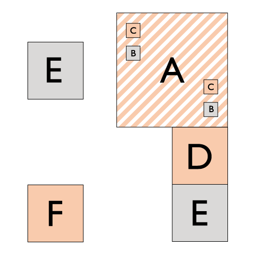
Figure 1
Indian Land Area Construction Overview
- A
- Reservation defined by land title documents of record
- B
- On-Reservation; Other trust, restricted fee, and mixed land status tracts.
- C
- On-Reservation; 100% tribal trust
- D
- Contiguous and 100% tribal trust
- E
- Off-Reservation; Other trust, restricted fee, and mixed land status tracts.
- F
- Off-Reservation; 100% tribal trust
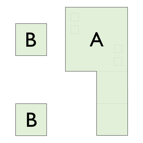
Figure 2
Creating a Land Area Representation (LAR)
- A
- Contiguous tracts are merged with the reservation
- B
- Off-Reservation tracts are merged with the reservation, if applicable, to create the LAR
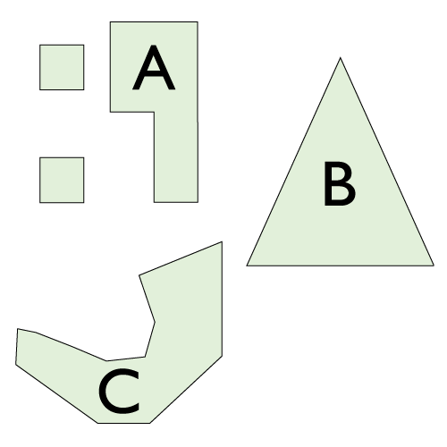
Figure 3
The Nation LAR Dataset
- A
- LAR A
- B
- LAR B
- C
- LAR C
Indian Land Area Construction Overview
- A
- Reservation defined by land title documents of record
- B
- On-Reservation; Other trust, restricted fee, and mixed land status tracts.
- C
- On-Reservation; 100% tribal trust
- D
- Contiguous and 100% tribal trust
- E
- Off-Reservation; Other trust, restricted fee, and mixed land status tracts.
- F
- Off-Reservation; 100% tribal trust
Creating a Land Area Representation (LAR)
- A
- Contiguous tracts are merged with the reservation
- B
- Off-Reservation tracts are merged with the reservation, if applicable, to create the LAR
The Nation LAR Dataset
- A
- LAR A
- B
- LAR B
- C
- LAR C
Each LAR is mapped individually and in stages. One stage is mapping the exterior of a reservation. Another stage merges the off-reservation trust, restricted fee, or mixed interest tracts with the reservation polygon to create the LAR for a given area. Each area is mapped separately. In the case where there is no reservation and only individual tracts of land, the tracts are merged together into a single polygon. The national LAR dataset contains all final LARs.
The land areas and their representations are compilations defined by the official land title records from the BIA which include: treaties, statutes, Acts of Congress, agreements, Executive Orders, proclamations, deeds, official surveys and other land title documents.
There is no impact on the legal status of the land areas depicted herein and no impact on land ownership. No legal inference can or should be made from the information in this GIS dataset.
The land areas and their representations are compilations defined by the official land title records of the BIA which include treaties, statutes, Acts of Congress, agreements, Executive Orders, proclamations, deeds and other land title documents. The trust, restricted, and mixed ownership land areas are suitable only for general spatial reference and they do not represent the Federal government’s position on the jurisdictional status of Indian country. Ownership and jurisdictional status is subject to change and they must be verified with plat books, patents, and deeds in the appropriate Federal and state offices.
Not necessarily because a LAR includes the exterior extent of Indian reservations and off-reservation trust, restricted-fee land, or mixed ownership interest tracts. Land owned by an Indian individual or a Federally-recognized tribe or non-tribal citizen may be located, and frequently is, within the exterior extent of a land area.
The dataset can be downloaded at the BIA BOGS sitemap and data.gov. The most recent version of the data can be downloaded or accessed from the BIA BOGS website.
Helpful links regarding this topic
These data have been developed from the best available sources. Although efforts were made to ensure that the data are accurate and reliable, errors and variable conditions originating from source documents and/or the translation of information from source documents to the systems of record (e.g. TAAMS and CAD NSDI/PLSS) are still possible. Users must be aware of these conditions and bear responsibility for the appropriate use of the information which include: possible errors, scale, resolution, rectification, positional accuracy, development methodology, time period, environmental and climatic conditions and other circumstances specific to these data.
The following are examples of inappropriate uses. Although this is not an exhaustive list, it is intended to illustrate the diligence required on the part of the user when evaluating the application of the data for a specific purpose.
- Inappropriate use would be a user relying on these data as a depiction of legal “ownership” and interpreting geographic acreage computations as the legal acreage of a parcel or tract of land without validation against official surveys and other land title records.
- Inappropriate use includes relying on these data to illustrate or to align with the extent of a particular tribal government jurisdiction or authority without validation with appropriate sources and official records.
- Inappropriate use includes use of the land area data to represent areas that are dedicated to conservation, preservation or other natural, recreation and cultural uses, and/or portraying the land area as areas managed for these purposes without validation with appropriate sources and official records.
- Inappropriate use includes use of these land areas to illustrate open space/resource lands or conservation easements without validation with appropriate sources and official records.
- Since only Federally-recognized tribe land areas are contained in this dataset, it is inappropriate for a user to rely on these data for the extent of state recognized tribe land areas.
The BIA LAR dataset’s spatial accuracy and attribute information are continuously being updated and improved. It is recommended that the user review the metadata for details concerning currency of the product as well as refer to the website for any updates for future releases.
Helpful links regarding this topic
LAR Sub category - LAR and Cadastral
These data are prepared strictly for illustrative and reference purposes only and they are not intended for legal, survey, engineering or navigation purposes, therefore, they should not be used for these purposes. In addition, these data are appropriate for general purpose reference graphics.
Where applicable, the dataset aligns with the CAD-NSDI PLSS. Not all states utilize the public land survey system. Therefore, it is possible that a section of a LAR is aligned to an approved local survey and alternate source that is not part of the PLSS. BIA BOGS suggest that tribes consult with the BLM Indian Lands Surveyor (BILS) for survey related questions.
Helpful links regarding this topic
The BIA coordinates with the BLM to obtain the PLSS enhanced with the Geographic Coordinate Database (GCDB) known as the Cadastral National Spatial Data Infrastructure (CAD-NSDI) dataset for Indian lands where available. The BLM and the Federal Geographic Data Committee (FGDC) are responsible for maintaining and publishing the PLSS. The BIA uses the CAD-NSDI PLSS to align the land area representation data for reference purposes. The BIA monitors the geometry for correction due to any potential shift resulting from geoprocessing in the final national LAR dataset that may deviate from this reference grid. Customers may contact the BIA Branch of Geospatial Support regarding any alignment questions.
Helpful links regarding this topic
The Public Land Survey System (PLSS) is a way of subdividing and describing land in the United States. All lands in the public domain are subject to subdivision by this rectangular system of surveys, which is regulated by the U.S. Department of the Interior, Bureau of Land Management (BLM).
Helpful links regarding this topic
The BILSs' primary responsibilities will include consultation and guidance for BIA employees, tribal governments, and individual Indians concerning boundaries, surveys, land ownership, resource management, and other legal and technical survey matters related to Indian trust including restricted and fee lands. The BILSs will also provide assistance in the following areas:
- Boundary survey issues
- Fee to trust process
- Probate process
- Land description reviews
- Inventory of survey needs
- Resource management
- Cadastral GIS
- PLSS within Indian Country
Helpful links regarding this topic
- Certified Federal Surveyors Program (CFedS)
- Certified Federal Surveyors Program (CFedS) Frequently Asked Questions (FAQ)
A Federally-recognized tribe is an American Indian or Alaska Native tribal entity that is recognized as having a government-to-government relationship with the United States with the responsibilities, powers, limitations, and obligations attached to that designation, and it is eligible for funding and services from the BIA.
These governments may represent culturally distinct tribes or bands. For example, the Confederated Tribes of Coos Lowe Umpqua and Siuslaw Indians are recognized as one Federally-recognized tribal entity. Not all Federally-recognized tribes have a LAR.
Helpful links regarding this topic
GIS datasets (feature classes and standalone tables) relate through unique IDs. For example, LARs relate to Federally-recognized entities through unique IDs in the GIS datasets. These relationships can be complex because several Federally-recognized entities may share a LAR. For example, the Wind River LAR is associated with two distinct Federally-recognized entities: Eastern Shoshone Tribe and Northern Arapaho Tribe.
The BIA LAR dataset has IDs that relate to entity codes (see Table 1 and 1.1). The entity table can join or relate to the LAR dataset through the IDs.
Table 1.0
Table 1.1
The BIA LAR dataset has IDs that relate to entity codes (see Table 1 and 1.1). The entity table can join or relate to the LAR dataset through the IDs.
| Entity ID | Entity Name | LAR ID | LAR Name |
|---|---|---|---|
| T0593 | Arapaho Tribe of the Wind River Reservation | LAR0208 | Wind River LAR |
| T0594 | Shoshone Tribe of the Wind River Reservation | LAR0208 | Wind River LAR |
| T0542 | Paiute Indian Tribe of Utah
|
LAR0365 | Kanosh LAR |
| T0540 | Navajo Nation | LAR0052 | Navajo LAR |
| T0287 | Federated Indians of Graton Rancheria, California | LAR0130 | Graton LAR |
| LAR Name | LAR ID |
|---|---|
| Wind River LAR | LAR0208 |
| Kanosh LAR | LAR0365 |
| Navajo LAR | LAR0052 |
| Graton LAR | LAR0130 |
Alaska Native Regional Corporations (ANRC) are corporate entities organized to conduct both for-profit and non-profit affairs for Alaska Natives pursuant to the Alaska Native Claims Settlement Act. ANRCs have legally defined boundaries that subdivide all of Alaska into twelve regions together with a thirteenth Regional Corporation comprised of natives who are non-permanent residents of Alaska. Metlakatla - Annette Island Indian Reservation is the only Reservation in Alaska.
Helpful links regarding this topic
- BIA Branch of Geospatial Support Maps and Data downloads
- U.S. Domestic Sovereign Nations: Alaska Native Federal Land Areas map
In Oklahoma, historic depictions of the land areas representations, as described in 1867-1870, were developed and called Tribal Statistical Areas (TSA) in the LAR. These areas are similar to the Bureau of Census Oklahoma Tribal Statistical Areas (OTSA) which are areas used for the collection, tabulation and presentation of decennial census data for the 36 Federally- recognized American Indian tribes located in the state. No legal inference can or should be made from the TSA information in the GIS dataset.
Reservation boundary data is limited in authority to those areas where there has been settled Congressional definition or final judicial interpretation of the boundary. Absent settled Congressional definition or final judicial interpretation of a reservation boundary, the BIA recommends consultation with the appropriate tribe and then the BIA to obtain interpretations of the reservation boundary.
Reservation boundary data is limited in authority to those areas where there has been settled Congressional definition or final judicial interpretation of the boundary. Absent settled Congressional definition or final judicial interpretation of a reservation boundary, the BIA recommends consultation with the appropriate tribe and then the BIA to obtain interpretations of the reservation boundary.
Since the data are public information, they may be used and interpreted by organizations, agencies, units of government, or other entities. However, the user, agency or organization has sole responsibility for ensuring the appropriate use, application, integration, republication, alignment and interpretation of data derived from it. Inappropriate use can lead to misrepresentations, misunderstandings, unfounded assumptions and errors in data derived from this product.
No, the BIA is still working to develop representations for Alaska, and in many other locations where there are limited legal land description reference materials research will be required. Newly mapped locations will be added to each new release of the LAR as it becomes available.
The BIA does not provide a warranty for using the data for purposes not intended by the BIA. Data users should also note that the GIS dataset may contain errors. The GIS dataset is to be used solely for illustrative, reference and statistical purposes and it may be used for government to government tribal consultation.
If these digital data are used in the production of a report or in the compilation of a stand alone printed map, then this dataset is to be cited in the report or on the map using the source citation specified below.
Map
“Polygon data representing the depictions of American Indian and Alaska Native Land Area Representations are provided by the Bureau of Indian Affairs.”
- Organization:
- BIA, Office of Trust Services, Division of Land Titles and Records, Branch of Geospatial Support (BIA OTS DLTR BOGS) or (BIA)
- Title of dataset:
- Example - BIA American Indian Alaskan Native Land Area Representation or BIA AIAN National LAR
- Version:
- Data storage (schema or structure) version
- Publisher Name:
- Bureau of Indian Affairs Branch of Geospatial Support
- Publication Date:
- When the dataset was last exported and published
- Date Accessed:
- mm/dd/yyyy
- Web access information:
- Website address
- Format:
- Organization. Title of dataset. (Version). Publisher name, Date of publication. Date accessed. url of data
Examples
DatasetU.S. Bureau of Indian Affairs. BIA AIAN National LAR. (2.1). BIA Branch of Geospatial Support, 12/08/2018. 12/22/2018. < https://bia-geospatial-internal.geoplatform.gov/datadownload.html >
Map
U.S. Bureau of Indian Affairs. U.S. Domestic Sovereign Nations: Lands of Federally-Recognized Tribes (Lower 48). (ANSI A, 12/2018). BIA Branch of Geospatial Support, 12/2018. 12/22/2018. < https://bia-geospatial-internal.geoplatform.gov/gallery/PDF/IndianLands_ANSI_A_v8.pdf >
For more general questions and answers, see the Bureau of Indian Affairs, Frequently Asked Questions (FAQ).